Seoul in 1951 during the Korean War vs. Seoul today
Sunday, April 26, 2009
If you feel like exploring the streets of Seoul yourself after this, check out Daum's Road View service (here's a random starting point), pretty much the same as Google's Street View. After the pictures though is a much larger list of some good places to start from, so scroll down to see those.
Now for the pictures:
First, the Euljiro area downtown. Korea Bank can be seen near the middle at the intersection there.
 The same area today:

Seoul Station:
 The city was taken over three times during the war and there are some pretty poignant pictures at the War Memorial here as well showing snipers on the rooftop for example as it was a pretty good vantage point at the time. Now it looks like this:

 That's where you can take the high-speed train (the KTX) and others to the rest of the country. You can explore the area starting from here.
Getting on the train in 1951:

Getting on (and off) the train today:

The Chosun Hotel in 1951 (established in 1914):
 And now:

Some street in the city, no idea where:
(Edit 2017: apparently this is the view looking south from the intersection of Sejongno and Jongno.)
 Some street in the city today:
 People by the Han River in 1951:
 People hanging out by the river today:
 Namdaemun in 1951:

I wish I could say that this was Namdaemun today:

...but some nut burned it down last year. Now it looks like this:
 You'll never guess why it was burned down. There was this 69-year-old guy that wasn't happy with the money he got from selling this land to developers...so as a protest he decided to burn the gate to the ground.
Han River in 1951 with mountains in the background:

Han River today:

This is a stream that flows through Seoul called the Cheonggyecheon (청계천):
 This stream was actually covered by concrete later on, and then in 1968 a highway was built over top. The stream still flowed underneath though and in 2003 the mayor of Seoul (now the president) decided to restore it, and this was completed in 2005. Before 2005 this area (Euljiro 4-ga Station for example) was actually a pretty crappy neighborhood, with a lot of shops selling lighting and textiles and whatnot, and the raised highway overhead just added to the industrial feel. But now that the stream has been restored it looks like this:
 and sometimes like this at night.

Kids playing on the street in 1951:

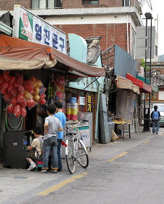
Kids playing on the street today:
 These pint-sized arcade games on the street are positioned at just the right height for kids to sit down and play.
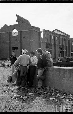
Finally, what appears to be a bit of hanging out amongst the ruins in 1951:

Compared to hanging out at the PC bang (pc room) today.

Now for the links to some interesting places to start from when using Daum's Road View (originally from here):
- The road in between the COEX convention centre and the temple
- A bridge going across the Han River
- King Kong with a backpack climbing up a building
- Itaewon, where the largest non-Korean population lives and close to the American army base
- Here's a nice park in the middle of the city that I like. For some reason they walked around to film here so you can pretend to stroll around the park too.
- Here's the airport.
- Apparently this is the mountain where gangsters take people that owe them money for a quick beating and then a long walk home. See this blog post for details.
- Global Standard Doosan WE'VE. We've what? They're not telling.
- McDonalds, Starbucks, and a poster for the Dark Knight. Now you know when the images were filmed.
- Here's a language school, where lots of people sign 1-year contracts to teach English in...and then more and more contracts one after another until they become lifers and can't leave the country anymore.
- Seoul Station, where you can get on the high-speed train. Those armoured buses are for riot police.
- Starbucks!
- Finally, no city tour would be complete without the requisite "look at me, I'm awesome" statue.


2 comments:
Great work! I'm sending this page out to a bunch of friends. Great job showing the amazing development of Korea.
Great! In a history course i took Korea's economy had a comparative rapid recovery from the war with a major export in human hair for wigs and what not. On a personal note my mom used to live outside of seoul in the north and has a shrapnel scar on her wrist from the war. Where she grew up is now part of Changdong. Growing up with Korean parents who survived the war has been interesting to say the least; from hearing of stories of my dad seeing General MacArthur pass by in a jeep, to seeing poor students with lice in their hair, rummaging through garbage for food and getting scared off by American soldiers... I always resented my dad for literally making me eat every single kernel of rice off my plate. Its nice to reconcile these idiosyncrasies with visual proof. Histories of wars usually focus on the military and economic effects and not so much on the sociological. The comparison photos really captures the Korean mentality then and now. Thanks.
Post a Comment